2.24.2007

Perito Moreno is Radically Dull

Not to be confused with the Perito Moreno Glacier, Parque Nacional Perito Moreno, or the hundreds of Argentine streets named after Perito Moreno, the town of Perito Moreno--which lies partway along the RN-40, an unending dirt highway running parallel to the Cordillera--is incredibly dull. We thought that nothing could quite rival the bleakness of the Atlantic coast's Puerto San Julian, but Perito Moreno manages to.

Emily and I had the amazingly bad luck to pull into town late on a Saturday, fresh off a grueling 14-hour bus ride from El Chalten. While the rest of our fellow travellers fought over a handful of rooms at the inelegant Hotel Belgrano (every one else on our bus would leave very early the next morning), we trudged over to the municipal campground to pitch our tent in a dusty parking lot that proved the least hospitable surface for staking a tent in the entire southern hemisphere. Also, having spent fourteen straight hours staring out the window at vast nothingness, we were perplexed why it was necessary for our fellow campers to pitch their tents six inches to either side of our own. But, we were tired, so we went to sleep.

Our objectives for the next day were fairly straightforward--find food, find someone to take us to the nearby Cueva de los Manos Pinturas archeological site, get the hell out of dodge. By the end of the day, we'd only barely managed to find food. We spent nearly the entire day trudging down desolate Av. San Martin waiting to see if any businesses would honor their posted hours. No dice. We did see a young boy fanning himself with the propeller from his toy helicopter, and some other kids waved at us from behind drawn curtains, shouting "Hello! Hello!" at us in English. In the afternoon, we amused ourselves by pushing a discarded cow backbone around with our boots, and reading political graffiti blaming the U.S. for Perito Moreno's woes. We also spent some time pondering why the town's Burma Shave-style sign was spelled backwards.

The grocery store never did open its doors, but a few other places did open long enough for us to patch together something resembling a meal. The owner of the local fruit stand was unwilling to look away from a TV showing crowd shots from a local soccer match (when you don't spring for the pay-per-view feed, you get this unending footage of fans watching the game, which is like the only thing on the planet more boring than soccer). His wife begrudgingly agreed to sell us apples, grapes, eggs, and avocados. The gas station, which also doubles as the local watering hole, had dusty bottles of $2 wine and cartons of dulce de leche for sale. And a local rotisserie had bread and homemade alfajors. We brought these ill-matched ingredients back to the campground and pondered how it could have all gone so wrong.

Fortunately for our psyches, we were not the only ones to come to grief in Perito Moreno. Our most visible neighbors at the campground were a group of six twentysomethings driving a giant pickup with "Expedition 2007: The Southern Cone" emblazoned on the door. We watched on Sunday morning as they spent countless hours stripping down their site. To give you some idea of the work involved, they had a giant propane tank attached to a hot plate on a folding table, all for the sole purpose of boiling water for mate. They disappeared in the afternoon, however, for what we thought was for good. As we were choking down our dinners, though, they rolled back into the dusty campground to again pitch their tents. They still hadn't learned the lesson that a) no amount of hammering will successfully get a tent stake into the ground in Perito Moreno and b) there are at least 500 more efficient ways to boil your mate water. After our respective preparations, we all turned in early, dreaming about our next day's escape route. -NSH

On To Fitz Roy

With the Torres del Paine circuit under our belts, Emily and I decided to continue north to check out Argentina's answer to Paine--Parque Nacional Los Glaciers. Home to two impressively ominous peaks--Monte Fitz Roy and Cerro Torre--plus a plethora of other granite spires, calving glaciers, and emerald lakes, the park is like a taller but more compact version of its (in our opinion, superior) Chilean cousin.

Fitz Roy and Torre both boast contentious and fascinating climbing histories, and the park still plays host to countless climbing teams, whose visible presence makes the trekkers in the park something of a subspecies. Because we're both sort of fascinated with climbing without having the mental or physical desire/ability to hunker down in ice caves or pull ourselves up vertical slopes, we enjoyed watching documentaries on ascending Fitz Roy and Torre from the warmth and comfort of El Chalten's National Park Visitor's Center. We then ventured into the park to observe climbers firsthand.

The first site we stayed at--Campamento De Agostini--played host to trekkers and climbers alike. The former are recognizable by their modest tents, loose-fitting clothing, and tendency to admire nature from a distance. The latter--who tend to spend long days and weeks at base camp waiting for the weather to clear--are distinguished by their gear-laden campsites, spandex everything, and enormous stone and wood monuments erected out of boredom.

Despite their differences, Parque Nacional Los Glaciers has much to offer both climbers and trekkers. Walking the moraine ridge beside Laguna Torre on the first afternoon of our hike, Emily and I admired Cerro Torre's cloudless spire in shorts and t-shirts, not realizing that the view was like a once-a-week stroke of good fortune. By the next morning, the peak was completely engulfed in fog, and rain pelted us as we hurried to Campamento Poincenot, the site nearest to Fitz Roy.

We spent two incredibly cold nights at Poincenot--socks, pants, fleece, and wool hats in our mummy bags cold--using it as a base for exploring a variety of spur trails. We walked partway into Laguna Sucia on an unmarked boulder-hopping route, but were stopped by the fast flowing waters of the lake's outlet stream. We also checked out the remote and very pretty Glacier Piedras Blancas, which is surrounded by enormous erratic boulders that make you feel ant-like as you scramble around them. Our hands-down favorite route in the park, however, was the rocky climb up to Laguna de los Tres, a beautifully blue glacial lake located 1500m. up above a treeless ridge. The clouds parted for the first time in two days to offer incredible views of the towering, wind-chiseled Fitz Roy.

We spent a mere four days in the park--less than half the time taken exploring Torres del Paine--but the bone-chilling temperatures of the final two nights, coupled with a sudden and intense aversion to tuna fish, minute rice, dried fruit, and other hiking staples, made us happy to emerge from the woods. When we pulled out our hiking guide the next morning, over cafe con leche at a hostel in El Chalten, we both agreed to nix future treks not involving geysers, fumaroles, and hot springs. -NSH

2.18.2007

Perito (Expert) Moreno Glaciar

Well before we had travelled to Argentina, we were hearing tall tales about the spectacular beauty of the Perito Moreno Glaciar, which was until a few years ago one of the world's few advancing glaciars. Friends informed us that the Perito Moreno was so beautiful its splendor would make us cry. Once we arrived in Argentina, everyone from our laundryman to random German hikers insisted that we absolutely had to see Perito Moreno. It's a pretty well-regarded chunk of ice, and we were looking forward to seeing it ourselves. The glaciar is named after Perito Moreno (and what isn't in this country?), although the man never saw it himself. Apparently he just missed discovering it, a feat that was left to a Chilean general who dubbed it the Bismarck Glaciar, a name which the Argentines apparently did not take to.

We spent the morning hanging out on boardwalks on the peninsula of land across from the glaciar, watching and listening for the frequent calving. Even though the position of the Perito Moreno has stabilized, the glaciar remains remarkable active, and very entertaining for the tourist.

After staring at the ice for a couple of hours, we took a boat across the Lago Argentino for a more intimate encounter with the glaciar, in the form of ice trekking across its surface. Glaciars are apparently not fetus-friendly locales, as I was only allowed to strap on crampons after promising on several occasions to several people that no, I was not pregnant. Our guide also informed us that the trip was not recommended for people with head problems.

We headed out onto the glaciar's vast crests and valleys with a mixed group of Argentines and foreigners, walking in between deep blue crevasses and sinkholes, past streams of cold meltwater running down into the Lago Argentino. We finished our trek with possibly the finest drink ever: a whiskey with glacial ice in a shallow glacial valley, which our guides poured with a liberal hand, reminding us that, after all, we didn't have anywhere to drive that afternoon.

2.08.2007

Inside the Sloth Cave

As mentioned many months ago--in a post about our trip to the Museo de Ciencias Naturales in La Plata--Emily and I have developed something of a fascination with the enormous, now-extinct mammal species that once roamed the pampas. One result is that we pretty badly wanted to visit La Cueva del Milodon--a giant cave near the Last Hope Sound in Chile, where perfectly preserved specimens of Giant Sloth (Mylodon Listai) skin and dung were discovered near the turn-of-the-century. We naively assumed that the cave was still as remote and off-the-beaten-path as when Bruce Chatwin visited it in the late 1970s, and that a great deal of hiking and orienteering from Puerto Natales might be necessary. In fact, for better or worse, the cave is now administered by CONAF, Chile's National Park Service, and excursions from Puerto Natales are both plentiful and popular. Because our legs were still pretty sore from Torres Del Paine, and because the hostel offering mountain biking excursions had already dicked us out of a room reservation (note to googlers: stay away from Patagonia Adventures) we shelled out for a remise to take us 25 km. out of town to see the cave for ourselves.

The story of the prized sloth skin's discovery is the cause of much debate. I still haven't been able to patch together a lone convincing narrative. The cave may or may not have been discovered by two Germans and a Swede who settled near Puerto Consuelo. The larger-than-life Francisco "Perito" Moreno supposedly rushed down from the La Plata museum to examine the giant piece of skin found by the Europeans. Presumably, the skin we photographed in La Plata is at least one part of the same specimen. Chatwin insists that one of his relations, Charley Milward, came away with "yards of skin and piles of bones and claws", but the interpretive center at the cave suggests that this is legend. One amusing detail that does appear to be true is that a London newspaper enlisted a skilled team of sloth hunters to deliver a live sloth specimen for the public. Although the team was led by "Expert" Moreno, they sadly couldn't fulfill their assignment.

Whether or not sloths and early humans used the cave at different times or, as some suggest, at the same time--the human hunters using it as a kind of corral for trapping the lumbering beasts--the place is undoubtedly impressive. Chatwin's description of sloth dung littering the floor is no longer true, but much of the rest holds: "The inside was dry as the desert. The ceiling was shaggy with white stalactites and the sides glittered with salt encrustration. Animal tongues had licked the back wall smooth. The straight wall of rocks dividing the cave had fallen from a fissure in the roof. By the entrance was a small shrine to the Virgin." Actually, strike that last part. Now there's a giant effigy of a roaring ground sloth. I guess that every once in a great while, time actually brings improvements. -NSH

2.05.2007

The Paine Circuit Continues... And Ends

On the morning of the fourth day, we hauled out of Refugio Lago Dickson without realizing that the prettiest campsites and most agreeable weather were already behind us. After a final glance back at Glacier Dickson—which looks like it’s coated with a fluffy white merengue—we swung west through drizzling rain, passing one of the fiery orange peat bogs that occur pretty frequently in Tierra del Fuego but seem less common farther north. The layout of the Circuit necessitates a campground in close proximity to Paso John Garner (more on that soon), which is probably the only reason that Campamento Los Perros exists. Easily the worst site on the route, it's a muddy, mosquito-infested patch of dirt that we were unlucky enough to greet in the pouring rain. We spent most of the evening in a cramped wooden shelter, watching a ubiquitous crew of hard-drinking Chilean boys cook a giant cauldron of pasta on a "portable" two-ton stove that folded up like a suitcase. Desperate for creature comforts, we bought overpriced cans of beer from the tiny almacen. I thought Emily was insane for asking if the beer was cold--everything was cold--but lo and behold, the beer was the lone exception. We drank it anyway, before crawling into our sleeping bags (wearing socks, pants, fleeces, and wool hats) for a really damp and unpleasant night.

Day Five is the most notorious of the trek--the one everyone tells horror stories about a few campsites later. In order to make a loop, it's necessary to pass over the ominous Paine massif somewhere, and the best place anyone's found to do it is at Paso John Garner, a 1200-meter high dip between snowy peaks. 1200 meters isn't all that high, and the climb to the pass would be pretty simple in agreeable weather. The problem is that the weather is never agreeable. The leg from C. Perros to C. Paso is rated "Difficult" because of the gale-force westerlies that sweep through the pass. They're literally enough to knock you over (we both left our feet on multiple occasions). What basically happens is that as soon as the wind dies down, you sprint like hell for the biggest rock you can find and cling to it. If you stand there clutching it long enough, the odds are pretty good that you'll see a couple passing you going the other way, with one person screaming "It's over!" and the other yelling "Fine! I never want to see you again!".

Really, the only good things about Paso John Garner are a) If you make it over, there are spectacular views of Glacier Grey and b) conquering it gives you license to be smug to the majority of hikers in the park, who do a much abbreviated route called the W. A book could probably be written about the difference between W'ers and Circuit'ers, but our own favorite observation is that while W'ers carry really expensive and techy equipment, it seemed to us that most Circuit'ers had things like the aforementioned two-ton suitcase stove. Anyway, immediately after making it over Paso John Garner, we both foolishly came to believe that we were "almost done" even though we had four-plus days of hiking ahead of us, and started doing things like eating twice as much food per meal as we'd rationed. I'm serious, the wind does things to your sanity.

Day Six spent much of the time skirting the east flank of Glacier Grey, a 5 km. wide and many-km. deep mass of intricately crevassed ice that represents one of the stubbornly remaining fragments of the rapidly melting Continental Sur. About midway through the day we encountered hikers with day packs coming the other way, which was pretty weird. We ate lunch out in the open, during the only 20 minutes of rain the entire day. We also passed through a pair of imposing chasms, watched Magellanic Woodpeckers shriek and flutter about, and ended up at a densely packed campground on a pebbly beach, with box wine for sale and hot showers for all (much rejoicing).

Day Seven brought us to the windy shores of the impossibly blue Lago Pehoe, which offered us our first impressive views of the imposing Cuernos del Paine. Late a night, a boat pulled up and unloaded dozens and dozens of French tourists who stayed up half the night guzzling wine and taking photos of totally banal sites, such as the campground's cooking shelter. By Day Eight we were really in the home stretch, working our way to Albergue Los Cuernos on a meandering path that brought us past yet another of the park's beautifully blue lakes. On the last morning, we woke up to a torrential downpour. Not patient enough to wait it out, we packed our tent up in the rain and finished the final 11 km. at a pretty brisk trot. If we'd known in advance how badly China Doll Grossman was going to botch things, we probably wouldn't have rushed it. -NSH

The Paine Circuit begins.

Nate and I postponed beginning our circuit for a day in order to hike to the base of the Torres del Paine, the sheer rock towers that give the Parque Nacional de Torres del Paine its name. In a fit of possible insanity, we decided to make a special effort to see the torres at dawn, when they are especially picturesque. To that end, we spent our first day hiking to a campsite an hour from the base of the torres, where we spent the night. We had planned to rise at the almost reasonable hour of five am, and make a quick trek to the look out point, but an overeager fellow trekker convinced us that we would be too late. To really see the torres at dawn, she said, we would need to rise at four am.

The next morning, as we hiked through the darkness with her, the extent of her overeagerness became apparent. While the days are long in Patagonia, they are not that long, and the sun does not rise at four. Also, it is very cold before the sun rises. We made our dark, cold way to the base of the torres, where we had plenty of time to enjoy pre-dawn views and practice our night photography. When the sun did finally rise, the views were, as promised, spectacular, with the rising sun briefly illuminating the torres with a striking orange glow.

We spent the rest of our long second day trekking ten kilometers to the start of the Paine Circuit, and reaching the starting point in time for lunch. After a well deserved hour of rest and stretching exercises, we set out for Puesto Seron, where we planned to camp next to an old puesto, a shelter that had been used for occasional overnights by workers on the ranches that surrounded Torres del Paine before it had been made into a national park. The walk to Puesto Seron was long but lovely, through fields filled with daisies. We arrived in the early evening, tired but mostly intact. While our bodies had made it through the long day, some key equipment was not so resilient. Nate's boots (loyal companions for ten years and three continents) were showing their age, as the heel and sole of one boot had begun to tear apart. We made some short-lived experimental repairs involving medical tape, but the future of our expedition seemed doubtful until a kindly park ranger supplied us with three precious, ancient tubes of super glue. We drained two of them, in a desperate attempt to keep the sole of the boot united with the upper portion. With one tube of super glue in reserve, we decided to press on the next morning to Lago Dickson.

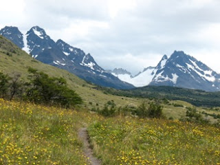
The route to Lago Dickson took us over grassy foothills covered with thorny calafate bushes and mogotes. From the hills we got spectacular panoramic views of the light blue Lago Paine and the Paine range. We also had our first glacier sighting, and our first encounter with the fierce winds of the park. We also encountered for the first time several of our fellow trekkers who would be completing the circuit at the pace as us: a quiet, fast walking Chileno who carried two backpacks, one on his back and one on his front, and two rather dapper Frenchmen, who spent hours preparing cafe au lait each morning and took lengthy and elaborate smoke breaks on the trail.

At the end of an exhausting day, our first sight of the Lago Dickson campsite was most welcome. We climbed a morraine to see the campsite far below us, on a peninsula surrounded by a lake floating with icebergs calved off the Dickson Glacier. We spent a mostly peaceful night there, interrupted only by the occasional whinnying of a herd of horses pastured nearby, and by a group of Chileno college students, who lugged a giant bottle of whiskey out to Lago Dickson, where they offered around whiskey on the rocks until the bottle was drained. Sufficiently well-liquored, they proceeded to swim in icy Lago Dickson. One assured me later that they had only done it to get pictures of themselves swimming with the icebergs. -EMW

Towers of Pain!

The recent gap in our blog entries is due to the fact that we spent the nine days prior to the Bears’ tragic defeat at Parque Nacional Torres del Paine, Chile. The park is famous for its jagged peaks, mammoth glaciers, and pristine lakes, and we’ve long been eyeing the Paine Circuit—a classic backpacking trek that touches most of the key areas of the reserve—as one of the must-do’s of our trip. We tacked a scenic side trip onto the route, bringing the grand total to eight nights, nine days, and over 125 kilometres logged by foot. The route boasts such a diversity of scenery—everything from meadows choked with daisies to boggy birch forests, sheer rock pinnacles to expansive ice fields—that it felt like we covered even more ground than we actually did. Regardless, we both felt like the park and its signature hike more than lived up to their lofty billing.

Because the trek chewed up so much of our time and digital camera memory, we thought we’d do at least a couple of different posts about it. For anyone familiar with the route (or anyone who’s especially curious), our itinerary worked out as follows: Hosteria Las Torres to Campamento Torres (Day One). Campamento Torres to Puesto Seron via Torres del Paine Lookout at dawn (Day Two). Puesto Seron to Refugio Lago Dickson (Day Three). Refugio Lago Dickson to Campamento Los Perros (Day Four). Campamento Los Perros to Campamento Paso (Day Five). Campamento Paso to Refugio Grey (Day Six). Refugio Grey to Refugio Lago Pehoe (Day Seven). Refugio Lago Pehoe to Albergue Los Cuernos (Day Eight). Albergue Los Cuernos to Hosteria Las Torres (Day Nine). –NSH.